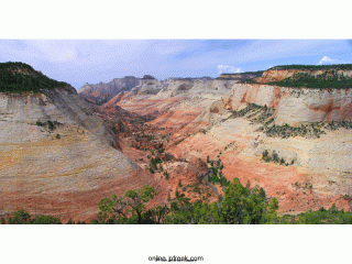
The path demands that you scramble up a short eight-foot cliff band. Soon you will come to the forested ledge just below, and east of the Checkerboard Mesa tabletop. Now it is necessary to switch direction and travel north, back toward Highway 9, hiking on top of the ledge. Stay to the right and just above the developing cliff so that you avoid even denser foliage up high. The use of game trails will make travel easier.
This route is simpler than trying to ascend to the base of the caprock that comprises the Checkerboard Mesa table-top. Continue north for several hundred yards to the promontory just north and below the actual tabletop. Soon the terrain will level out and spectacular views will appear. There is a good flat area to sit and have lunch. After lunch, walk around and marvel at the expansive views of slickrock country.
– GPS Coordinates:
WGS84 Datum
Parking
37°13.762 N
112°52.739 W
Hike End and Viewpoint
37°13.530 N
Related – Off the Beaten Path at Area BFE
* Published by JPFreek Adventure Magazine – The leader in Jeep and adventure enthusiast publications.
